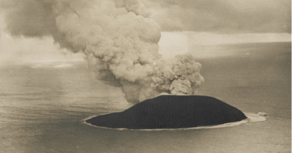
On November 14, 1963, a fishing crew off Iceland’s south coast spotted black smoke rising from open sea where no land had ever been charted. Within days, a brand-new island was rising out of the North Atlantic. More than sixty years later, that island is still there, and only a small number of authorized researchers and personnel have ever been permitted to land on it.
That island is Surtsey, and the question people keep typing into Google is simple: why is Surtsey Island forbidden? The short answer is that Iceland protects it as a nature reserve with strictly controlled access, not a tourist destination. The longer answer involves a volcanic eruption, a UNESCO listing, a tomato plant that arrived accidentally through human waste, and a handful of internet rumors that don’t hold up against the official record.
The question also raises several related mysteries. Some want to know if Surtsey Island is dangerous. Others are curious exactly how Surtsey Island formed in the first place, or whether the Surtsey Island conspiracy theories circulating online are worth taking seriously. This guide answers all of it, using official research and records from the scientists and institutions who have studied the island, rather than repeating the secondhand claims other sites recycle.
Why Is Surtsey Island Forbidden? The Legal Reason Behind the Ban
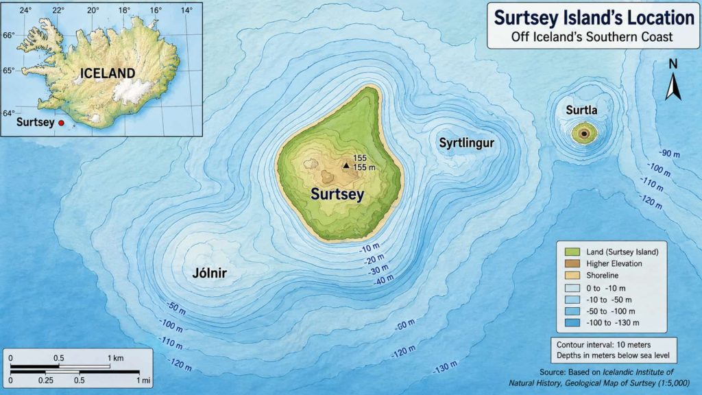
Surtsey Island is forbidden because Iceland declared it a nature reserve in 1965, while the eruption that built it was still going. The declaration was renewed in 1974 and again in January 2006, and now covers the entire volcano, above and below the waterline, plus the underwater craters Jólnir, Syrtlingur, and Surtla, and a marine buffer zone.
The Surtsey Research Society is responsible for coordinating authorized research and access under Iceland’s nature-reserve rules. Landing without the required permit is prohibited under the nature-reserve regulations. The goal isn’t secrecy; it’s keeping one patch of the planet free of human influence so scientists can watch life colonize newly formed volcanic land.
What the Official Rules Actually Say
The Surtsey Research Society’s published nature-reserve rules lay out exactly what’s banned on and around the island:
- No one may set foot on Surtsey without a permit from the Surtsey Research Society.
- Nothing on the island may be disturbed; even a permanent structure needs a separate permit from the Environment and Food Agency.
- No living animal, plant, seed, or plant part may be brought onto the island, deliberately or by accident.
- No waste of any kind may be left on or near the island.
- Firearms are banned within two kilometers of Surtsey.
By- wocomoDOCS
That last rule surprises most people, but it fits the pattern: this is a protected natural laboratory, and every rule exists to stop a human hand from tipping the results. None of this means Surtsey Island is dangerous to the outside world; it means Surtsey Island is forbidden purely to protect what’s happening on it. The restriction remains in place because protecting the island’s scientific value comes first.
How Was Surtsey Island Formed?
Surtsey Island formed during an eruption that started roughly 130 meters below the Atlantic’s surface, about 18 kilometers southwest of Heimaey in Iceland’s Vestmannaeyjar archipelago. It broke the surface on November 14, 1963, and kept building the island, with pauses, until it stopped on June 5, 1967. Eruptions like this are often preceded by an earthquake swarm, a warning sign geologists still watch for at volcanic systems worldwide, including more recently at Ethiopia’s 2025 volcanic eruption, though the exact signals vary between volcanic systems.
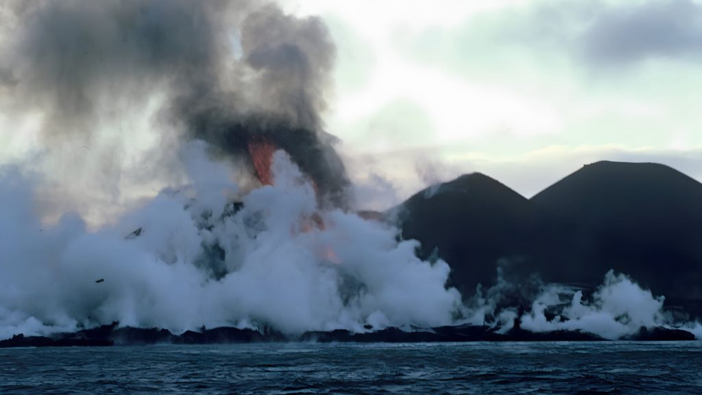
At its largest, the new island covered about 2.7 square kilometers and stood roughly 174 meters above sea level, according to NASA’s Earth Observatory. Icelandic authorities named it Surtsey in 1965, after Surtr, the fire giant of Norse mythology said to set the world ablaze at the end of time: a fitting name for an island still on fire when it got one.
The Vestmannaeyjar Volcanic System
Surtsey didn’t erupt in isolation. It’s part of the Vestmannaeyjar volcanic system, itself a piece of the Mid-Atlantic Ridge, where two tectonic plates slowly pull apart. The same system produced the 1973 Eldfell eruption on nearby Heimaey, the archipelago’s only inhabited island, which buried part of a fishing town just ten years after Surtsey was born.
Most of the archipelago’s other islands are uninhabited outcrops that count among the world’s other forgotten places, left to seabirds alone, though Surtsey is the one exception still watched this closely. That’s the full story of how Surtsey Island formed: three and a half years of eruption that built a permanent piece of Icelandic territory from nothing.
Is Surtsey Island Dangerous? Separating Volcanic Risk From Legal Restriction
Surtsey does not pose the kind of active-volcano threat people might expect. Its more immediate physical hazards come from unstable volcanic terrain, erosion, steep cliffs, and changing coastal conditions
NASA’s own monitoring notes that a single winter storm can noticeably reshape Surtsey’s coastline, since much of the island is still soft ash and tephra rather than solid rock. Cliffs along the southern shore have been worn back by wave action for decades, and gullies on the northern slopes keep shifting as rain washes debris downhill.
A 2024 aeromagnetic survey published in the Journal of Volcanology and Geothermal Research provided new detail about Surtsey’s internal volcanic structure and the surrounding submarine deposits, the kind of data that helps scientists understand how young oceanic islands like this one hold together underneath. The surrounding marine area is protected too, primarily to limit human interference with the ongoing research.
So the honest answer is layered: Surtsey Island is dangerous mostly because of its young, unstable, rapidly eroding terrain rather than any ongoing volcanic activity, and that instability is one more reason researchers, not tourists, are the only people allowed near it. The protected marine area also limits how closely vessels can approach the island.
Why Surtsey Is a Natural Laboratory for Primary Succession
Surtsey’s real significance goes beyond being an unusual travel restriction. It’s an exceptionally rare natural laboratory where scientists have watched an entire ecosystem build itself from bare volcanic rock, in real time, with a paper trail going back to day one. That timing lined up almost exactly with the publication of the theory of island biogeography by ecologists Robert MacArthur and E.O. Wilson, handing researchers a live natural experiment.
It’s part of why Surtsey Island is forbidden to casual visitors, and why people still ask whether Surtsey Island is dangerous to the research rather than to the public.
The scientific term for what’s happening on Surtsey is primary succession: the step-by-step process of life establishing itself on land that has never supported an ecosystem before. Most places where ecologists study succession, a forest after a fire, a field after farming stops, already have soil, buried seeds, and nearby life ready to move back in. Surtsey started from sterile volcanic rock with none of that.
The sequence researchers have documented runs roughly like this: bare tephra and lava first hosted bacteria, algae, and fungi, which slowly broke down rock into the beginnings of soil. Wind- and current-borne seeds followed, giving rise to hardy pioneer plants that could survive in thin, mineral-poor ground.
As those plants added organic matter, insects and other invertebrates arrived to feed on them, which in turn drew birds. Bird droppings added nutrients that let more demanding plant species take hold, gradually building toward the denser vegetation seen on parts of the island today.
Because researchers have documented the island’s ecological development from its earliest stages, continuously since 1964 rather than reconstructed after the fact, Surtsey gives ecologists something almost no other site can: a real-time, start-to-finish record of primary succession on a fixed timeline. That single fact is a central reason Surtsey Island is forbidden to nearly everyone, and that unbroken record is a large part of why Surtsey Island is forbidden to interference of any kind, no matter how minor it might seem.
How Did Life Reach Surtsey Island?
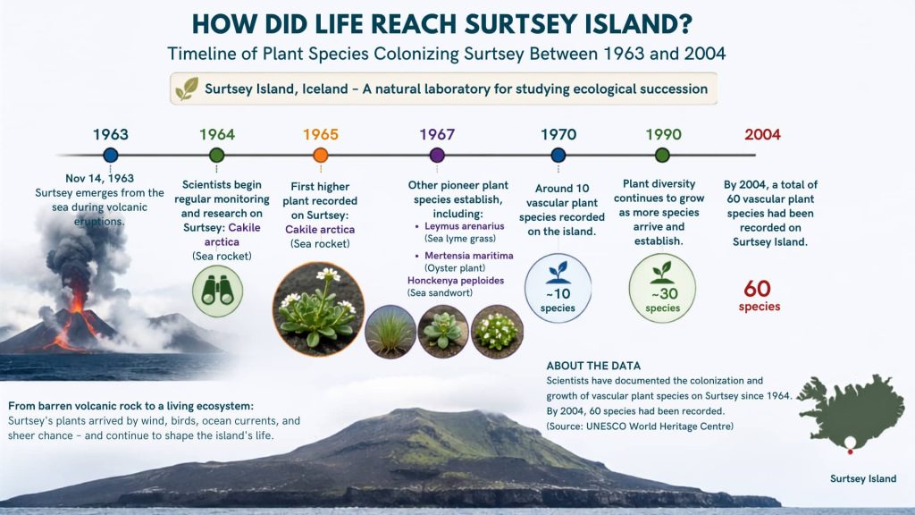
Scientists have tracked Surtsey’s biological colonization since 1964, a year before the eruption even ended, making Surtsey an exceptionally rare opportunity to watch an ecosystem develop from scratch. The first arrivals were invisible: seeds carried on ocean currents, followed by molds, bacteria, and fungi taking hold in the cooling ash.
The first vascular plant appeared in 1965, and ten species had gained a foothold by the decade’s end. According to UNESCO’s official listing, by 2004 that number had grown to 60 vascular plant species, alongside 75 mosses, 71 lichens, 24 fungi, 89 recorded bird species, and 335 invertebrate species. Scientists have had to identify and classify each new arrival as the ecosystem developed, using the same process any researcher follows when naming a newly identified species.
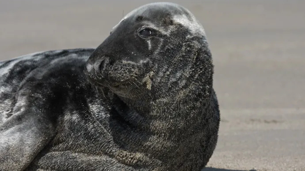
Marine life arrived too. Gray seals were resting on Surtsey’s shores within a few years of its birth, breeding there by 1982, according to the Smithsonian Institution. Orcas have since been spotted in the surrounding waters too, adding another layer to the island’s developing ecosystem.
The Surtsey Tomato Plant Story
In the summer of 1969, a researcher monitoring Surtsey’s plant life found something that shouldn’t have existed: an unidentified plant growing out of a soft pile in the lava. It turned out to be a tomato plant, sprouted from human waste left on the island.
Ágúst Bjarnason, the scientist who found it, kept the story quiet for 45 years before finally telling it publicly in an Icelandic newspaper, as reported by Iceland Review. The plant was destroyed the moment it was identified, since it represented an unintended human seed reaching soil meant to stay untouched. It’s a vivid real-world example of why Surtsey Island is forbidden to anyone without a permit, tomato seeds included.
Surtsey Island Conspiracy Theories: What’s Rumor and What’s Real
Because Surtsey Island is so hard to reach and so tightly controlled, a small cluster of conspiracy theories has grown up around it online. Several recurring conspiracy claims appear online, but the available historical and scientific record does not support them.
One version claims the Icelandic government or UNESCO is hiding unusual discoveries, from rare biology to something more exotic. Another suggests the island was secretly used for military testing because of its isolation.
A third links Surtsey to Atlantis or lost-civilization myths, simply because it’s new land rising from the sea. A fourth argues authorities downplay how much early researchers actually disturbed the ecosystem, to protect Surtsey’s untouched reputation.
None of this holds up against the documented record. Surtsey’s research has been published continuously since 1965, first as the Surtsey Research Progress Report series and later continued as the journal Surtsey Research, now up to volume 14, covering everything from plant colonization to drill-core geochemistry. The 1969 tomato plant incident, arguably the strongest evidence of unintended human impact on the island, wasn’t buried.
It was documented by name, by year, and eventually told publicly by the very scientist who found it. The documented tomato incident and the decades-long publication record provide no evidence for the commonly repeated cover-up claims. I found no credible evidence in the documented sources reviewed for this article supporting those Surtsey Island conspiracy claims.
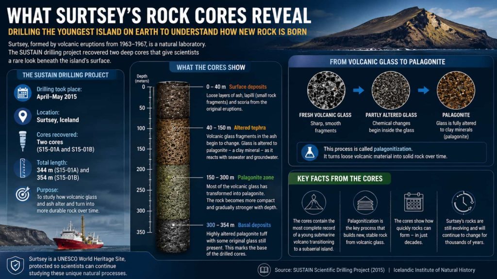
What Surtsey’s Rock Cores Reveal
In 2017, researchers on the SUSTAIN drilling project pulled two rock cores, 344 and 354 meters long, comparing them against an earlier 1979 core. Analysis at Lawrence Berkeley National Laboratory’s Advanced Light Source showed geologists exactly how volcanic glass turns into palagonite tuff, the hard rock that now makes up Surtsey’s interior, on a human timescale most volcanic islands never allow anyone to observe, according to Berkeley Lab. None of this makes Surtsey Island dangerous to visit hypothetically; the ban stands regardless of the geology.
Is Surtsey Island Disappearing?
Erosion has already cut Surtsey roughly in half. The island peaked at about 2.7 square kilometers in 1967 and had shrunk to around 1.4 square kilometers by 2008, according to Encyclopaedia Britannica. Wind and wave action are expected to keep eating away at the softer ash and tephra, eventually leaving only the hardest, most erosion-resistant core.
Estimates for how long that will take vary by source and year, worth flagging rather than presenting one number as settled. What’s consistent is the direction: Surtsey will keep shrinking, and the same instability that makes Surtsey Island dangerous to its own coastline is slowly erasing it. Erosion doesn’t change why Surtsey Island is forbidden; that legal reason has nothing to do with the coastline shrinking.
Surtsey Island Facts at a Glance
Here are the essential Surtsey Island facts, from its volcanic origin and changing size to its protected status and remarkable ecosystem. In short: Surtsey Island is dangerous mainly to its own unstable terrain, and here’s the short version of how Surtsey Island formed.
- Location: North Atlantic Ocean, about 32 km off Iceland’s south coast
- Formed: November 14, 1963 – June 5, 1967
- Named for: Surtr, the fire giant of Norse mythology
- Peak size: 2.7 km² (1967)
- Size as of 2008: 1.4 km² (Britannica)
- UNESCO status: World Heritage Site since July 7, 2008
- Managed by: The Surtsey Research Society, under Iceland’s Environment and Food Agency
- Access: Permit-only; authorized researchers and personnel
- Life recorded (by 2004): 60 vascular plants, 75 bryophytes, 71 lichens, 24 fungi, 89 bird species, 335 invertebrate species
Together, these Surtsey Island facts cover exactly how Surtsey Island formed, who can visit, and what happens next, all in one place instead of scattered across a dozen sites.
Future Research: What Scientists Still Want to Learn From Surtsey
Surtsey is no longer a brand-new island, but it remains an unusually valuable long-term scientific experiment. Researchers are continuing to study how volcanic land changes physically and how an ecosystem responds as the island itself becomes smaller.
One major question is how continued erosion will affect Surtsey’s developing ecosystem. Waves, storms, rainfall, and weathering are steadily removing softer volcanic material, reducing the island’s total land area. As the available habitat changes, scientists can track whether particular plant and animal species disappear, adapt, or are replaced by species better suited to the island’s changing conditions.
The island’s geology provides another long-term research opportunity. The SUSTAIN drilling project recovered deep cores from Surtsey, allowing researchers to examine how freshly formed volcanic material changes into more durable rock over time. Studies of the cores can help scientists understand processes such as volcanic glass alteration and the formation of palagonite tuff, while also providing a rare record of how young oceanic crust develops.
Surtsey also remains valuable for studying primary succession. Because scientists began documenting colonization soon after the island emerged, researchers have an unusually detailed record of how organisms arrived, established themselves, and changed the environment around them. Future observations can show how an ecosystem behaves as it moves from its pioneering stages toward a more established ecological community.
Another important question is how much of Surtsey’s future can be predicted from its past. Researchers have decades of observations covering vegetation, birds, invertebrates, geology, erosion, and marine life. Comparing these records over time can help scientists understand which ecological changes are temporary and which represent lasting shifts in the island’s development.
The island’s shrinking size makes this research particularly valuable. Surtsey will not remain physically unchanged forever, but the scientific record created while it exists provides an opportunity that cannot easily be repeated. Every new observation adds to a decades-long experiment that began when the first volcanic activity broke through the North Atlantic in 1963.
That is ultimately why continued protection matters. Surtsey’s future is not simply a question of whether the island will survive. It is also a question of what scientists can learn while a young volcanic island, its geology, and its ecosystem continue changing together.
Key Takeaways
- Surtsey Island is forbidden under Icelandic nature-reserve protections, enforced by the Surtsey Research Society since a declaration first made in 1965 and renewed in 2006.
- Surtsey Island formed in a volcanic eruption from 1963 to 1967 and was named after Surtr, the Norse fire giant.
- Surtsey Island is dangerous mostly because of unstable, still-eroding terrain, not active volcanism.
- Life colonized Surtsey from newly formed volcanic land, and scientists have documented its ecological development since 1964.
- Surtsey Island conspiracy theories about hidden discoveries or cover-ups aren’t supported by the island’s continuously published research record.
- Erosion has already cut the island’s size roughly in half since 1967.
Related Articles You May Like
- Heimaey, Iceland: Remarkable Volcano Island That Wouldn’t Die: Surtsey’s next-door neighbor in the Vestmannaeyjar archipelago, buried in part by its own eruption in 1973.
- Ethiopia Volcano Eruption 2025: a modern eruption preceded by the same kind of earthquake warning signs geologists watched for before Surtsey broke the surface in 1963.
- How Scientists Name a New Species (And Who Really Decides): the formal process every one of Surtsey’s colonizing species had to pass to become officially recognized.
- 10 Newly Discovered Species That Shocked Scientists: more recent finds that, like Surtsey’s early arrivals, redrew what scientists thought they knew.
- Deep-Sea Mining: What’s Really at Stake for Ocean Life: another case of researchers racing to document a fragile, barely understood ecosystem before human activity reaches it.
- Forgotten Places: the uninhabited islands and sites around the world left almost entirely alone, the same category Surtsey belonged to before it became a research site.
Frequently Asked Questions About Surtsey Island
Why is Surtsey Island forbidden?
Surtsey Island is forbidden because Iceland declared it a protected nature reserve in 1965, renewed in 2006, to preserve it as an undisturbed site for studying how life colonizes new land. Only scientists with a permit from the Surtsey Research Society may set foot on it.
Why can’t tourists visit Surtsey Island?
Any human presence risks introducing seeds, organisms, or disturbance that would compromise decades of ongoing colonization research. Visitors can only view the island from a distant boat or aircraft.
Is Surtsey Island dangerous?
Not in an active-volcano sense, since the eruption that formed it ended in 1967. The real risk is unstable terrain: loose ash, eroding cliffs, and a coastline storms can reshape in a single winter.
How was Surtsey Island formed?
Surtsey Island formed during a submarine eruption that began about 130 meters below sea level and broke the surface on November 14, 1963, continuing on and off until June 5, 1967.
Who is allowed on Surtsey Island?
Only researchers holding a permit from the Surtsey Research Society, authorized by Iceland’s Environment and Food Agency, and even they follow strict rules once ashore.
Are the Surtsey Island conspiracy theories true?
No verified evidence supports them. Surtsey’s research has been published openly since 1965, including incidents of accidental human impact like the 1969 tomato plant, which contradicts the idea of a hidden cover-up.
Is Surtsey Island disappearing?
It’s shrinking. Erosion cut the island from about 2.7 km² at its peak in 1967 to roughly 1.4 km² by 2008, and wind and wave action are expected to keep wearing it down toward its hardest volcanic core.
What are some interesting Surtsey Island facts?
Surtsey emerged from the North Atlantic in 1963 and was named for Surtr, the fire giant of Norse mythology. Iceland later protected the island, which UNESCO added to its World Heritage List in 2008. Since its formation, researchers have recorded hundreds of species gradually establishing themselves on the new volcanic land.
Is Surtsey Island dangerous to boats sailing nearby?
The main purpose of the restrictions around Surtsey is conservation rather than protecting boats from an active eruption; the surrounding waters are also subject to protective restrictions. The main reason access is restricted around Surtsey is conservation rather than an active volcanic threat, not maritime hazard, even though eroding cliffs and shifting shallows add a genuine safety margin worth respecting.
Can you visit Surtsey Island?
Not without a scientific permit from the Surtsey Research Society. General tourists cannot land, which is exactly why Surtsey Island is forbidden to casual visitors, though it can be viewed from a distance without landing.
Are boats allowed near Surtsey Island?
Iceland maintains a marine buffer zone around the island under the nature-reserve rules, so recreational boats and tour vessels can’t approach the coastline directly or land. Surtsey can be viewed from boats operating around the Vestmannaeyjar area, but landing on the island always requires a permit.
Source References
- Surtsey Research Society, “Friðun Surtseyjar” (Protection of Surtsey), english.surtsey.is: https://english.surtsey.is/fridun-surtseyjar/ (accessed 2026)
- UNESCO World Heritage Centre, “Surtsey”: https://whc.unesco.org/en/list/1267/ (listing since 2008)
- NASA Earth Observatory, “The Infant Island of Surtsey, Iceland”: https://earthobservatory.nasa.gov/images/4499/the-infant-island-of-surtsey-iceland
- Smithsonian Ocean, “A Unique World Heritage Site: Surtsey, Iceland”: https://ocean.si.edu/ocean-life/marine-mammals/unique-world-heritage-site-surtsey-iceland
- Iceland Review, “Dirty Secret Uncovered: Doing Business on Surtsey”: https://www.icelandreview.com/news/dirty-secret-uncovered-doing-business-surtsey/ (Feb 12, 2015)
Author Bio
Evan Brooks, author at StrangeHappen.com, writes about strange events, unexplained mysteries, unusual wildlife, ancient discoveries, and the science behind stories that seem almost too strange to be true. He enjoys digging through old reports, forgotten cases, and unusual claims to uncover what really happened.
His work looks beyond the mystery without taking away the sense of wonder. From eerie encounters and unexplained phenomena to bizarre creatures and ancient secrets, he separates documented facts from rumors, legends, and internet fiction.